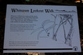
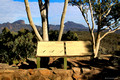
Copyright - All Rights Reserved - Black Diamond Images 2011General InformationWith some side detours the up to 14km round trip walk up to the Grand High Tops in the Warrumbungle National Park is well worth the effort and for that reason it is regarded in the top 10 walks in Australia.
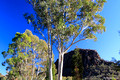
The walk departs from the Pincham Car Park with much of the track across Wallaby Flat beside the usually dry creek on level paved ground with gradual but increasing steepness till the stairs are reached. The last section which takes about an hour requires steep ascent of more than 500 steps with a final walk of about 30 minutes over very rough ground adjacent the Bread Knife before finally scrambling up to the Grand High Tops.
Allow 4-5 hours minimum to do this 12.5km walk. The grade is marked as 'moderate to steep'.
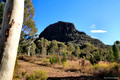
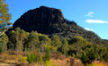
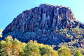
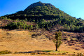
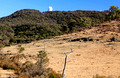
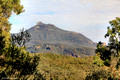
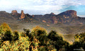
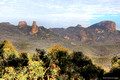
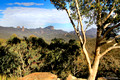
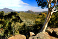
Once at the top the view is amazing with all the high peaks visible as far as Bluff Mountain, Mount Exmouth and Siding Springs Observatory while behind you is the impressive Crater Bluff. Directly below is the well named 'Breadknife' which can be seen in the near centre of this image. Belougery Spire is approximately 400m east of the Grand High Tops marker cairn and is over 500m high. It takes at least 3 hours for skilled climbers to ascend to the top.
This walk is definitely not recommend for anyone with arthritis or fitness or mobility issues.
Warrumbungle National Park is situated 35 km west of Coonabarabran and 80 km from Gilgandra in Central Western NSW. Access to the Park from Coonabarabran is by the bitumened Timor Road which becomes John Renshaw Parkway.
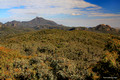
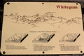
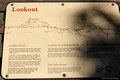
There are many points of interest along the way including White Gums Lookout, Siding Springs Astronomical Observatory and a plethora of astronomical letterboxes, private astronomy telescope shelters and several large roadside educational astronomy billboards associated with Siding Springs Observatory.
The Warrunbungles are considered one of the best night sky viewing points in Australia due to lack of nearby urban light pollution sources.
A gallery of images of
Coonabaraban, Siding Springs to Bellata